|
|
NATAL
«Back to Home
«Back to Basics
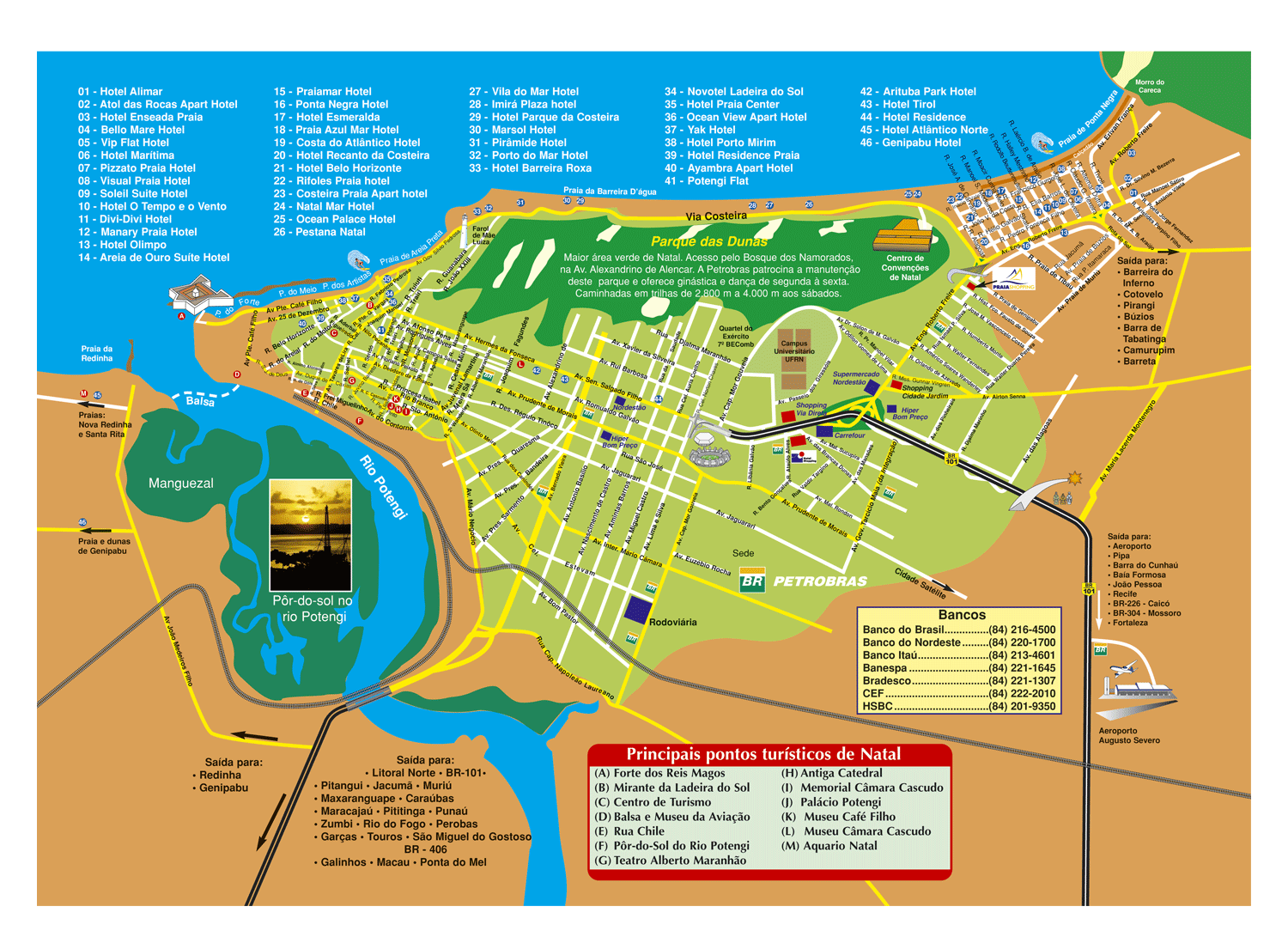
Natal is not big; it's not difficult to get yourself familiarized with it.
First off, click to open a
Map of Natal
in another window (file is big, 359 kB). The image is 1500x1098 pixels; notice that, if you are using WindowsXP, the image may have been automatically resized to fit in the screen; to bring it back to normal size, place the mouse over the image and click the "Expand" button which appears on the right lower corner.
 Now, scroll the page to the bottom and to the right. Look for the airport icon. Either you
arriving to Natal
by plane of over land, you will first enter the city via highway BR-101 (to get to the beaches and to return, you will take other roads), represented by the two large black strips; a bit ahead of the airport, the Three Wise Kings under a star welcome you.
Now, scroll the page to the bottom and to the right. Look for the airport icon. Either you
arriving to Natal
by plane of over land, you will first enter the city via highway BR-101 (to get to the beaches and to return, you will take other roads), represented by the two large black strips; a bit ahead of the airport, the Three Wise Kings under a star welcome you.
Go a few more kilometers down BR-101; the first bridge you see is the intersection to Ponta Negra; you will probably drive across this bridge many times.
Take to the right at the intersection and you will be at Avenida Engenheiro Roberto Freire; follow this avenue all the way down to get to Ponta Negra, the most famous of Natal
beaches
(Ponta Negra is the name of the village and of the beach; there are
hotels
in both). On the way, you will see supermarkets (Nordestao and Hiper Bom Preco), two mid-sized shopping centers (Shopping Cidade Jardim and
Praia Shopping), and, at the very end, the
Ponta Negra Beach
with famous Morro do Careca. About 10 km separate the intersection from Morro do Careca.
Still in Ponta Negra: notice the Av. Erivan Franca, which starts right off Morro do Careca; that's the stretch of beach where most of fun happens.
Back to the intersection: if you follow BR-101 straight up, you will see it changing names, first to Avenida Senador Salgado Filho then to Avenida Hermes da Fonseca; drive all the way up and you will reach the
beaches of Praia dos Artistas, Praia do Meio and Praia do Forte (look at the icon of the
Fortress of Wise Kings, where
Natal was founded, right on the bank of River Potengi). Following this way, you will see:
Natal Shopping Center
and
Via Direta Shopping
(represented in the map by the two red rectangles across the road from each other), the Machadão stadium, and then a long business street until the beaches.
Notice that, paralalell to Salgado Filho, there is a street called Prudente de Moraes, which also leads to the beach; that's another thorougfare of Natal. Towards the end of this avenue, where the map gets denser, you find the oldest part of Natal, where several
museums and monuments
are located.
Now, notice that, connecting Ponta Negra and Praia do Meio, there is a 10km road called Via Costeira. By one side of Via Costeira, you find
the best hotels in Natal; by the other side, you have
Parque das Dunas, a large piece of protected Atlantic Forest.
Now that you know how to drive around Natal, let's get off to the beaches outside Natal.
To get to the southern beaches, there are two ways. To go to beaches closer to Natal, like
Pirangi, you take Rota do Sol; that's the yellow road starting in Ponta Negra and going off the right side of the map. To go to more distant beaches, like Pipa, you will drive back to BR-101 and then drive south.
To get to the northern beaches, again two ways. To closer beaches, like
Redinha
and
Genipabu, you can either take the boat which gets across the river (the dotted line) and then continue from there. Or, look for avenue Bernardo Vieira, which makes crossing with avenida Salgado Filho, and just keep driving (and reading the signs).
Now, go back to reading Natal Brazil, and enjoy Natal.
Back to Top
|
|