|
|
Maps and Pictures of Natal and Rio Grande do Norte«Back to Home
Maps
 »Map of Natal Comments about the main avenues and gateways of Natal.
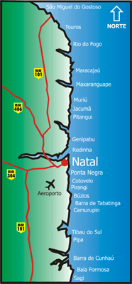
»Map of Rio Grande do Norte Important cities of the State
»Transportation in Rio Grande do Norte Map with roads, railways, ports and airports in the State
»
Brazil by States
shows Brazil divided by States
»
Brazil, RN, Natal
shows the state of Rio Grande do Norte and the city of Natal in the Brazilian map
»
Brazilian borders
Brazil in South America
»
Map of Natal
BIG file. 359 kB. Size: 1500x1098 pixels
»
Beaches
the beaches in the coast of Rio Grande do Norte
»Federal highways
Map and condition reports of federal roads near Natal
Pictures
»Check out this great selection of photos of Natal, selected by the Tourism Board of the city of Natal.
»Other pictures are scattered all across this site; visit the section of interest to see them. For example, to see the pictures of Ponta Negra beach, go to:
Home > Where to Go > Beaches Guide > Ponta Negra
Back to Top

visitors since April 5th 2005
|
|
